If you’re travelling a long distance by train in Ontario, then Via Rail’s service offerings are fairly well suited, with reserved seating and limited stops. And if you’re travelling a shorter distance, GO Transit’s service is well suited, with turn-up-and-go ticketing, and fairly frequent stops. But for intermediate distances between 100 and 200 kilometres or so, neither company offers a particularly attractive option.
Via Rail’s tickets are for a particular seat on a particular train, and the prices fluctuate wildly depending on when the ticket is booked. So in practice to get an affordable ticket, you need to book far in advance. For long distances that’s not as big of a deal since people tend to know in advance when they’ll travel. But if you’re only heading somewhere two hours away, you often won’t know weeks in advance exactly what time you’ll want to depart.
GO Transit offers fixed ticket prices and unreserved seats, so you can just show up at the station and take whichever train shows up next, without facing a harsh financial penalty like you would on Via Rail. They currently operate some longer services from Toronto such as to Barrie (101 km) Kitchener (103 km), Niagara Falls (130 km) and they between 2021 and 2023 they also ran 185 km to London. But the problem with those services is that they are not fast enough to be particularly attractive for such long distances. Outside of peak periods, most trains on those routes make all stops, which makes them too slow to be attractive for such long trips.
The ideal solution for these medium distances is what I call “Regional-Express” – a service approaching the speed of an intercity service (Via Rail) but while still maintaining the operating style of a regional service (GO Transit).
October 2023 marked the end of the two-year “pilot” of GO train service to London, which extended a single weekday Kitchener Line round trip beyond Kitchener. Because the service was introduced without any infrastructure investment, it was too slow and infrequent to be at all useful and therefore failed to attract any significant ridership.
In the 2022 provincial election, the Progressive Conservative party promised $160 Million in railway upgrades between London and Kitchener to make the service actually practical. The party was elected, now holding a majority of the seats in the Legislature, but they seem to have forgotten about this promise.
2022 election province of the PC party, who currently form a majority government.
In the 2021 budget of the Government of Canada, there is an item named “Next Step towards High Frequency Rail in the Toronto – Quebec City Corridor, with a budget of $491 million over 6 years.
This is in itself a concerning development, since the HFR project proposed by VIA Rail requires at least $4 billion. The 6 year timeline is also suspiciously long for a “next step”, which could be a sign of the government rejecting the proposal while trying to avoid admitting that they have done so.
2021 Budget item for VIA Rail upgrades
On the bright side, at least there is $491 million allocated for railway upgrades. Now the question is what that money will actually be used for. Two good candidates for investment would be the railway lines already owned by VIA that are included as part of the proposed HFR route: the Smiths Falls subdivision between Smiths Falls and Ottawa, and the Alexandria subdivision between Ottawa and Les Coteaux, QC (just west of greater Montréal).
Here are some cost-effective upgrades that would be possible along the Smiths Falls and Alexandria subdivisions:
Vehicle Actuation is a simple mechanism which is remakably effective at determining the “right” duration for a traffic signal phase. It repeatedly checks the activity on one or more vehicle detectors to determine when the traffic flow rate in a lane has dropped below a certain threshold and the green should therefore end.
This is not to be confused with Traffic Adaptation, which is a much more complex system which does active calculations based on aggregated traffic information to determine the optimal green durations based on metrics such as vehicle delay and number of stops.
While Traffic Adaptative systems are commonly labeled as “smart” signals in the media, many of the actions that road users may commonly associate with smart signals are actually the result of actuation, not adaptation. These can include varying the combination of phases based on the users present, providing tailored green waves for groups of approaching vehicles, and ending the green at precisely the right moment when a queue has cleared.
Hamilton Centre station a great example of an integrated transit terminal. In a single facility there are GO Transit regional trains and buses, Greyhound and Coach Canada intercity buses, and Hamilton Street Railway local buses. Having all these different agencies operate out of a single facility makes transfers between services easy, which benefits all services involved. But the station’s integration isn’t just limited to transit services. It also provides some of the best bicycle parking options of a station in Ontario.
I did a walkaround of the station to tally up the parking options available, and here’s what I found.
York University GO Station was my local train station for many years. But for most of that time, I never used it because it was only served by two trains per weekday, which were not at useful times for me. In more recent years, I used it a bit more, thanks to an ever-increasing number of train departures. But after the end of 2017, I will likely not be using the station at all – as it is planned to be closed permanently. In its place will be the new Downsview Park station at Sheppard Avenue, on the new extension of the TTC’s subway Line 1.
The decision to close York University GO Station has not yet been finalized, but it would be rather difficult to justify maintaining the station. It currently serves only 225 passengers per weekday, which makes it the least-used train station in Toronto. And it’s not hard to figure out why – it’s nearly impossible to get to. The station is located deep in an industrial area, so there is little to no walk-up traffic. There is no car parking, so park-and-ride isn’t an option either. There are also no public transit connections – the only bus which serves the station is a private shuttle operated by York University for its members. That shuttle only connects to certain weekday train trips, and there is no service at all on weekends. Not being a York University member, the only ways I could access the station were to cycle on some rather unfriendly North York roads or get someone to drop me off with a car.
York University Station surroundings. (Image from Google Earth)
As with any station closure, there is some amount of controversy. Over the past couple years, there have been periodically been protest posters and petitions plastered on the fence at the station, and more recently the CBC published a story featuring people who are upset about the possible closure.
According to a York student, “it would be a disaster” to travel from the GO Train to York University on a subway train rather than a bus, because there could be subway delays. And according to the York University manager of transportation, the new configuration would add 20 minutes to the trip to campus for train passengers coming from the north.
But the article fails to point out that neither of these statements are based in reality. While subway delays certainly do exist, the same is true with any mode of transportation. And in general, a subway line will be more dependable than an individual bus driving in mixed traffic between the campus and the station. And whereas the current shuttle bus only connects to select weekday GO trains, the subway will operate frequently all day every day, thereby connecting to every GO train departure.
This afternoon I visited Vaughan Metropolitan Centre to see the progress in one of the largest urban transformations underway in Ontario. The City of Vaughan, with a lot of help from York Region and the Province of Ontario, is turning a big-box commercial area best known for Ikea and Wal-Mart into a high-density mixed-use centre featuring highrise office and residential towers. The hub of the development is Vaughan Centre station, which will be the interchange between the Toronto Transit Commission’s Line 1 subway and York Region Transit’s Viva Purple bus rapid transit line.
I was impressed by a lot of the transit infrastructure I saw, especially Vaughan Centre station. I was also happy to find a relatively pleasant pedestrian environment along Highway 7 for such a busy and high-speed road. But my pleasant experience was abruptly ended when I decided to cross Highway 7 to head back along the other side of the road.
In November 2011, City of Toronto council voted to introduce separated bicycle lanes on Richmond Street, Adelaide Street, Simcoe Street and Peter Street, creating a continuous network of bicycle routes through the core of the city. Prior to the Richmond-Adelaide bicycle route project, the financial district had been a notable blank spot in the city’s cycling network.
The backbone of this new part of the bicycle network is the Richmond-Adelaide route. It consists mostly of separated bicycle lanes on Richmond Street and Adelaide Street, a pair of one way roads that form the main east-west motor traffic route into the financial district from the Don Valley Parkway.
Strengths
In general the Richmond-Adelaide route is a huge improvement over the previous options for cycling through the centre of downtown. It also includes some notable steps forward in important areas of design.
When I was in my third year at the University of Waterloo, I lived in the west end of town, off Keats Way. My commute by bicycle commute was generally quite enjoyable by North American standards, it took place almost entirely on quiet streets or in dedicated bicycle lanes. And it was very fast too! The 2.1 km trip took about 8 minutes, and if I was lucky with the one traffic signal, I could make the entire trip home without stopping once.
Here was my route, categorized by my comfort level (green is relaxed, red is stressed):
The worst part of my journey was making the right turn off University Avenue onto Keats Way. Right-turning cyclists share the right turn lane with motor traffic turning right, which often results in motorists speeding past and cutting in front of cyclists to save a few seconds. Even when drivers would remain a safe and respectful distance behind, I felt pressured to ride quickly to avoid delaying them, adding stress to my otherwise relaxed commute.
Cyclists travelling straight along University are also exposed to this same conflict, as the bicycle lane runs between the through lanes and the right turn lane. While it’s not statistically clear that this is actually a dangerous situation, it certainly feels very unsafe – making cycling along this route an unattractive prospect for the majority of people.
Keeping the bike lanes always on the right of the traffic lane rather than merging them together would completely eliminate interactions with motor traffic for right-turning cyclists. This would move the conflict point onto the actual intersection for through cyclists, where it can be addressed separately.
I think that the best solution here would be fully-protected signal phases. This means that turning cars and bicycles would each have their own dedicated signal, which only allows one to proceed while the other is stopped at a red signal.
The usual way of managing this conflict – where turning cars yield to bikes and pedestrians – would be considerably more dangerous. In order to allow large vehicles such as GRT’s Route 29 bus to make the turn, the corner radius needs to be very large. This would then translate to high turning speeds for cars, which increases the risk that a car fail to yield to a cyclist or pedestrian crossing Keats Way.
Here’s what the intersection could look like with protected bike paths and traffic signals:
Overhead view of a fully-protected Keats Way and University Avenue
Protected signal phases can actually be implemented efficiently here because the bulk of the movements are compatible with each other. For the most part, people are travelling straight along University or turning off Keats Way to/from the east.
Hardly anyone makes a left turn from University to Keats Way or a right turn off Keats Way onto University since this would be basically sending them back the way they came. This last signal phase would therefore hardly ever occur:
Last week I gave a quick overview of the new Queens Quay Boulevard bicycle path, which has been completed between Spadina Avenue and Bay Street in Toronto. It is a joy to ride, being laterally separated from motor traffic as well as from pedestrians. But there is one area which can be stressful: pedestrian-bicycle conflict points. Fortunately this issue is quite easy to fix.
Two issues typically occur at these conflict points. During the green light for east-west bicycles, many pedestrians inadvertently wander into the path of bicycle traffic, and during the red light for bicycles (green for north-south pedestrians), many cyclists stop too far forward, blocking the crosswalk.
Pedestrian’s view crossing Queens Quay – It’s easy to miss the bike path.
It seems fairly obvious why pedestrians could easily wander into the bicycle path. At these conflict points, it is paved in the same tiling pattern as the sidewalk, delineated only by tiled elephant’s feet. While these may be the correct markings to put in such a location, the fact that they are made of tiles makes them easy to mistake for simply another aesthetic flourish like the tiled maple leaves.
The solution to this issue is to make the path obvious by extending the asphalt paving through the pedestrian crossing point. Ideally there would also be a slight elevation change – a ramp down to the cycle track and back up on the other side – but that would be unreasonably expensive to retrofit at this point.
The explanation for cyclists stopping in the wrong location also seems fairly obvious. At intersections, the bicycle path has a large blue square, followed by a white bar then the granite-tiled pedestrian crossing point.
What is the road trying to tell me?
I spend a great deal of time looking at road designs all over the world, yet it took me a while to figure out what all these markings were supposed to mean. The blue box seems to be some sort of stopping area, but it covers the entire width of the path, which does not make sense. If people were to wait all the way across the box, they would be blocking people going the other direction. Similarly the white bar is presumably a stop bar, but since it also covers the entire width of the path, it is unrecognizable as such.
This confusion can be easily eliminated by using the standard North American road markings that we’re all familiar with. Here’s what a typical intersection would look like with these changes. Technically the centre line should be a single dashed line to indicate that overtaking is permitted, but I’m not as concerned about that.
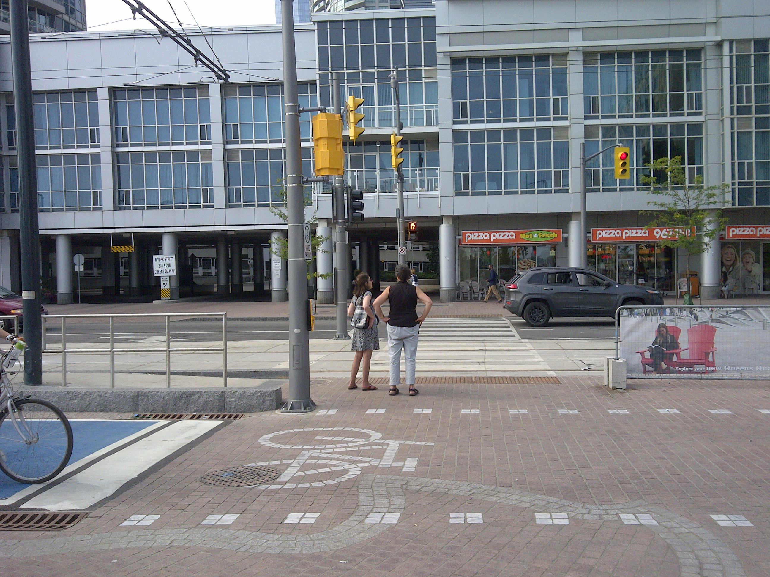
There are a couple intersections where this standard design might not work as well: York Street, and Spadina Avenue.
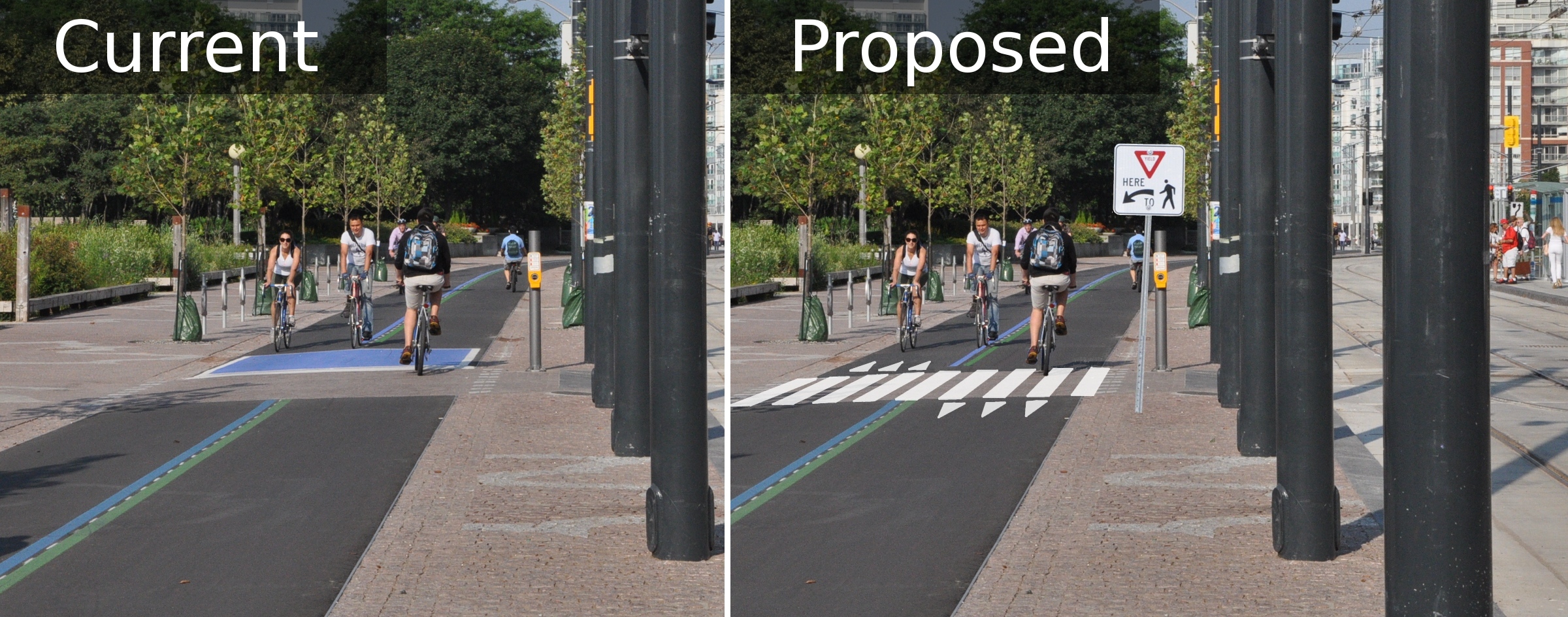
At York Street there is a very large distance between the pedestrian crossing point and the eastbound bicycle signals. It is not reasonable to expect cyclists to stop before the pedestrian crossing and remain there until the light turns green, since cyclists will be able to clearly see when it is safe to proceed to the edge of the roadway crossing.
In this case, I think the pedestrian crossing can be treated separately from the traffic signal, since there is a sufficient distance between them for cyclists to react to them independently. A simple priority arrangement would do the trick: either pedestrians would be given priority by adding a zebra crossing and a pedestrian crossing sign, or bicycles would be given priority by extending the asphalt through the crossing and adding bicycle markings for clarity. Here’s what it would look like with pedestrian priority:
At Spadina Avenue, there are no signals for the bicycle path at all. Since there is very little space for pedestrians to wait between the bicycle path and the signalized intersection, I think the only option is to formalize pedestrian priority using a zebra crossing and a sign. Here’s what that would look like:
I have very high standards when it comes to cycling infrastructure. So the fact that the issues I have with this path can be addressed with measures as simple as pavement markings is a testament to the quality of the design. Waterfront Toronto really nailed the basic design of the street, and with these conflicts clarified, the street would be on par with international best practice.