This afternoon I visited Vaughan Metropolitan Centre to see the progress in one of the largest urban transformations underway in Ontario. The City of Vaughan, with a lot of help from York Region and the Province of Ontario, is turning a big-box commercial area best known for Ikea and Wal-Mart into a high-density mixed-use centre featuring highrise office and residential towers. The hub of the development is Vaughan Centre station, which will be the interchange between the Toronto Transit Commission’s Line 1 subway and York Region Transit’s Viva Purple bus rapid transit line.
I was impressed by a lot of the transit infrastructure I saw, especially Vaughan Centre station. I was also happy to find a relatively pleasant pedestrian environment along Highway 7 for such a busy and high-speed road. But my pleasant experience was abruptly ended when I decided to cross Highway 7 to head back along the other side of the road.
Because it took me almost four minutes to do so.
I crossed at Highway 7 & Interchange Way, which is the western edge of the current road reconstruction project. This intersection is one block away from the Vaughan Centre subway station set to open at the end of 2017, so the number of pedestrians will be rapidly growing over the next few years.
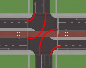
Here’s the rough layout of a standard intersection along Highway 7, oriented normally so north is up. Highway 7 & Interchange Way has a slightly different median arrangement, but it’s generally consistent with this diagram.
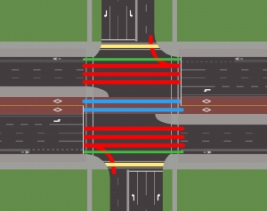
In the video I walk from southwest corner to northeast corner along the west side and north side crossings. The north-south crossings are two-stage crossings, meaning that there are separate pedestrian signals for each half of the crossing. Pedestrians have a whopping 43 metres to cross, including 7 general purpose lanes, 2 bus lanes, 2 bicycle lanes and a wide median which at some other intersections includes a bus stop.
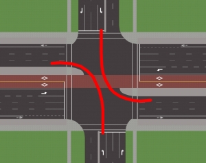
The phase sequence is as follows:


The missed opportunity here is phase 3/7. Cars are crossing turning left across one of the halves of the north-south pedestrian crossing, but since there are no right turn lane for eastbound traffic, there is no eastbound right turn green arrow. All east-west traffic sees a red display, so the walk light for the other half of the north-south crossing could overlap with this phase. And since it is always followed by phase 4/8, it could stay in Walk for the entire duration of phase 3/7 – allowing that phase to remain vehicle-actuated.

After all, given that we have two-stage pedestrian signals, we might as well get some benefit from them.
In the video, if the Walk indication for the first half of the crossing had started along with phase 3, I would have been halfway through the second half of the crossing by the time the Flashing Don’t Walk began, easily crossing Highway 7 in one go. This would have saved me a whopping 2 minutes of delay, as you can see from the other pedestrians who realized the pedestrian signals were lying and started walking during the middle of phase 3.
The likely reason that the pedestrian signals don’t overlap with phases 3/7 is that like almost all other signals in York Region, this is a Semi-Actuated Type 2 (SA-2) intersection. That means that the Walk light for the side street is only displayed if someone pressed the button. Managing pedestrian calls with overlaps and callable phases would get complicated, and I guess York Region would just rather not bother.
But given that the side street is busy enough to warrant a left turn phase, there must also be enough traffic that putting the pedestrian signal on recall wouldn’t have much impact. To accommodate the volume of motor traffic, side street green will be fairly long regardless of whether a pedestrian presses the button. So the walk light might as well come up every cycle. Then it would be very simple to set up pedestrian overlaps for one of the north-south pedestrian stages.
Pedestrian traffic is the lifeblood of any urban centre, so if Vaughan and York Region want their new development node to be more than just a traffic jam, they should start considering the pedestrian experience in the traffic signal timings.


9 replies on “Neglecting pedestrians in Vaughan Centre”
That is a problem for sure, but the root of the problem is having such a gigantic massive enormous road in your downtown core.
But I guess that ship has sailed. Out of curiosity are those bike lanes segregated in any way?
LikeLike
Yeah, that’s the fundamental issue here. If the Region were more proactive in their effort to reduce the almost 100% mode share of cars there, they might not need such enormous, inefficient and expensive roads.
The bike lanes are not segregated at all. The initial plan was 1.8m ordinary painted bike lanes, but the public found those laughable: who on earth is going to ride a bike on Highway 7 – with 6 lanes of 80km/h traffic (notwithstanding the 60 km/h limit) – separated only by 0.1 metres of paint? So they went back to the drawing board and came back with buffered bike lanes: a 1.4m bike lane and a 0.4m buffer. Which as you can add up, is exactly the same thing.
So these bike lanes will be horrendously underutilized in summer and completely unusable in winter. And the really frustrating part is that if they were physically separated, they could have had separate pedestrian crossings, cutting down the distance pedestrians need to cross during the side street signal phase.
LikeLike
True, but this is the world we live in. That being said, even with enormous oversized roads necessary today, it would be possible to put the station mid-…”concession”….I’m not sure what to call it, these aren’t “blocks”. Either way, between Highway 7 and the next major road, and built between them, and then the pedestrian area would be separate from the enormous roads.
As for the bike lanes, how stupid, 1.8 meters next to highway 7, they’ve basically just thrown out some more money. There is no reason to bother putting in bike lanes like that.
LikeLiked by 1 person
Thank you for bringing this intersection to light. I have had to cross this intersection numerous times recently. The experience has been trying and dangerous. To say nothing of the fact that it is a butt-ugly place, and a long way from anywhere.
Firstly, as seen in your video many of the turning cars do not want to stop. And why should they? Their priorities are obviously in the ascendence on these roads. Not even so much as a tap on the brakes. The black Merc turning left across your path is typical. I was nearly hit by a white Audi turning right from Edgley onto 7 last week as I walked south across the same crossing. I had the light, I was not obscured by anything, the sun was out. The guy was just the second or third car to try to bully past the pedestrians crossing.
You take your life in your hands in this intersection. Every day. Twice.
Another point — pedestrians crossing southbound across the same intersection are more or less obliged to treat the intersection as a two-stage crossing. And because York region has clearly posted signs telling you as such, they are washing their hands of responsibility to pedestrians.
But the most egregious aspect of this intersection was entirely missed in your article.
Many of the YRT buses (including Viva, Zum) running northbound drop commuters in the morning on the southeast corner about 50m south of the intersection. (Many do a reverse-flow commute to work in the area, i.e. coming from either Downsview or Finch subway.) The sidewalk for most of that 50m is currently closed because the path is still being completed, although it is not clear whether the developer or the city is doing the job. Pedestrians are obliged to walk in traffic to get to the southeast corner of the intersection, or jaywalk to get to the southwest.
And it gets better.
Many people disembarking the buses would want to stay on the east side of the street. The WalMart is on the east side, numerous industrial plazas hide behind the WalMart, and it appears that the office tower is now open. However the crossing on the east side of the street is closed and the pedestrian signals are bagged to hide them. Pedestrians are expected to cross from the southeast corner to the southwest, wait for the two-stage crossing you show in your video, and then cross again from the northwest to the northeast corner. Total time, about 8-10 minutes.
However most pedestrians do not want to wait. They may have been commuting for over 90 minutes by the time they get to this point. Between that facetiously unreasonable expectation, and the speedy indifference of the drivers, it is only a matter of time before we see pedestrians injured.
Welcome to Vaughan, “The City Above Toronto”.
LikeLiked by 1 person
Thanks for the incredibly detailed and on-point comment! There’s so much to go on here.
Your first issue is undeniably correct. York Region has a remarkably pedestrian-hostile design precedent that breeds non-compliance in yielding. People rarely stop at a red light when they’re turning right, they just blast through the crosswalk without checking. In the video, the black Kia at 1:50 races around the corner, and that’s fine because there is a right turn green arrow. But the Honda at 2:10 arrives at a red light and still rushes through, stopping only when the driver realizes that there is an imminent collision with other cars. The default assumption was that it would be possible to turn without stopping, even though it is not possible to confirm that the crosswalk is clear at more than a couple kilometres per hour if there are cars waiting at the red.
I have a few guesses as to the design factors which contribute to non-yielding behaviour:
– Massive corner radii enabling high turning speeds.
– Frequent situations at signals when drivers could safely turn at moderate speed (because there are no conflicting movements), but they are not shown a green arrow.
– Adding extra far-side lanes to minimize the chance of yielding. The classic example is merging lanes, but often they’re not as visible as that: there’s just more lanes than are actually needed. See for example how most entrances to residential areas from arterial roads have two lanes heading away from the arterial, only to immediately narrow down to one.
All these factors contribute to people getting used to not yielding, then carrying that behaviour over into places or times where they really do need to yield while turning.
Fortunately there are indications that the Region is slowly improving in these aspects. And there are even some signs of improvement on Highway 7.
– Turning right onto Highway 7, the radius directs right-turning cars around the bike lane rather than into it, which results in a lower effective radius (and lower speeds) than otherwise. Admittedly the resulting radius is still exceedingly large but it’s at least a sign that the designers were thinking about the issue.
– At some of the signals, including Interchange/Edgeley, there are some right turn arrows to highlight the times when motorists can safely turn right on red without stopping and checking. By extension, the absence of green arrow highlights the times people actually need to stop and yield.
– However there are still plenty of surplus egress lanes on the newly reconstructed Highway 7. At East Beaver Creek for example, there is only one northbound through lane on the near side, yet there are two egress lanes on the far side. The only purpose of the second lane is to reduce the chance that a driver turning off Hwy 7 need to yield – now they only conflict with pedestrians, and there aren’t that many of those. Which looks great on paper or in a simulation, because it reduces delay. The problem is that it also erodes the habit of yielding which is so absolutely necessary at this and other locations. And that second effect is never considered in the models.
Unfortunately, these design issues have a cumulative effect. No individual intersection has a significant effect on driver behaviour, but all intersections combined have a large effect. Which explains why the Honda at 2:10 blasted through the red light even though that exact movement also has a green arrow during another part of the cycle. This intersection on its own is not enough to make drivers unlearn the bad habits, but if it became standard across the province to consider the effect of road design on driving habits, that might just be enough.
The lack of east-side crosswalk is definitely a massive inconvenience. But I never mentioned it in this article because it is merely a temporary disruption caused by construction. The crosswalk exists, it’s just blocked off at the moment. Same with the other sidewalks. They’ll soon exist and they’ll be better than ever.
LikeLike
I calculate that in a well designed street, that there would be just 21 metres to cross. Link here to a design that I came up with: http://streetmix.net/CyclingEdmonton/749/hwy-7
According to my calculations, that enables a crossing time of just 17.5 seconds as opposed to the 35 the countdown has now, and assuming a minimum green time of 4 seconds, that allows for a phase of 21.5 seconds although that can be an extended walk light if required. Also, there would be easily time to give away to pedestrians depending on the direction of traffic that actually gets green, I suggest that the lights are red by default, you have to actuate them yourself if you want a green regardless of mode.
As for the minor side road, assuming a width of 13.4 metres (3 m thru lanes, 2.7 m left and right turn lanes and 2 m median in the middle), the time to cross that would be 11.2 seconds, including the minimum green it would be 15.2 seconds, minimum cycle time without turning traffic is 36.7 seconds, much more efficient, including the minimum green time for turning vehicles (4 sec green, 3 sec amber, no clear time) is only 50.7 seconds.
And assuming that pedestrians were no factor, then the minimum cycle time would be 28 seconds and up to 21 seconds of delay. Given that much of the time pedestrians would not press their buttons, this would be quite efficient.
LikeLike
– Highway 7 has 6 general purpose lanes, 2 bus lanes and 2 bike lanes. Your design has 2 general purpose lanes, 2 bus lanes and no bike lanes (they’re provided off-street, I assume). That’s an enormous difference, and one that is virtually unthinkable in Vaughan because this is an almost entirely car-dependent community. To justify such a massive motor traffic capacity restriction on a trans-provincial motor traffic route such as Highway 7, you’d need a comprehensive plan to provide the necessary transportation alternatives along other routes. In this case, that would probably require a new parallel highway.
– The minimum width for any lane on an arterial road is 3.0 metres. That would mostly apply to left- and right- turn lanes. Keep in mind that a bus is 2.9 metres wide (2.6m body + 2x 0.3m mirrors), so if you want to allow them to move at any more than walking pace (i.e. anywhere other than a turn lane), you need to provide a lane that is at least 3.3 m wide. For a dedicated bus lane, you’d want a width of 3.5 – 4.0 m to avoid slowing down buses on a facility whose entire purpose is to speed them up.
– The countdown isn’t 35 now. It probably should be, but it’s 16. That’s actually the whole issue here. There isn’t enough time to cross the street.
– There’s no point in resting in red, because volumes along Highway 7 are high enough a fully-actuated signal would never be resting during the day. Better to rest in east-west green, which is what currently happens. And since there’s so much traffic along Highway 7 that you’d hardly ever get that phase to gap out, you might as well determine the phase length in advance and provide Walk for as much of it as possible. Which is also what currently happens.
That said, the general concept of your suggestions is sound. Smaller intersections can work more efficiently because they need less all-red clearance (it cannot always be zero!!!) and less pedestrian clearance time, both of which allow for shorter phases and therefore shorter cycles.
LikeLike
They cant put a pedestrian signal in Phase 3. It’s not Left Turns only, it’s U-Turns as well.
LikeLike
Yes, northbound U-Turns are permitted during phase 3, which is northbound left and northbound thru. But that’s fine because they don’t conflict with any north-south pedestrian crossings, they only conflict with the east-west pedestrian crossings. I think you’re thinking of phase 1/5 which is east-west left turns and U-turns off of Highway 7.
LikeLike