Westheights Drive is a “community collector street” providing access to the Forest Heights neighbourhood in southwest Kitchener. It is currently a 4 lane street, with parking permitted in the curb lanes.
A look at the streetscape quickly reveals that it is completely inappropriate for its residential context. The layout gives the impression of an arterial road, promoting speeds well in excess of the 40 km/h limit, and allowing aggressive driving such as overtaking on the right.
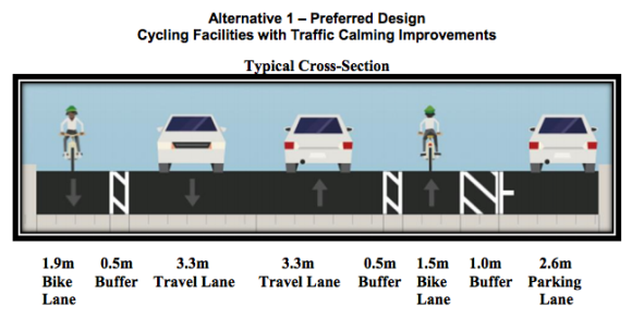
To fix these problems and create a street that is respectful of the neighbourhood it serves, the City of Kitchener is planning a “road diet” on Westheights Drive. The proposed design rearranges the street into two bicycles lanes, two motor traffic lanes and one lane of on-street parking.
This design represents best practice in on-street painted bicycle lane design. It provides lanes that are comfortably wide, with a further 0.5 m separation from motor traffic. Conflict areas at intersections are coloured for added visibility. And most importantly, there is a wide buffer between parked cars and the bicycle lane, keeping cyclists safely away from opening car doors.
The most striking negative aspect of the design is that the parking lane is positioned to the right of the bicycle lane, which means that cars will conflict with cyclists while parking. But this arrangement is warranted by the number of driveways along the street, which necessitate clear sightlines. And once the new road layout is in place, traffic will travel much more slowly and predictably, reducing the need for lateral separation between cyclists and motorists.
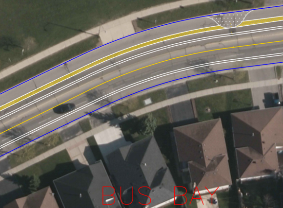
But there aren’t driveways everywhere. The segment in front of Westheights Park and Westhights Public School has no driveways on the north side of the street. This segment also includes the signalized intersection with Driftwood Avenue.
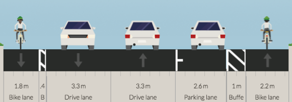
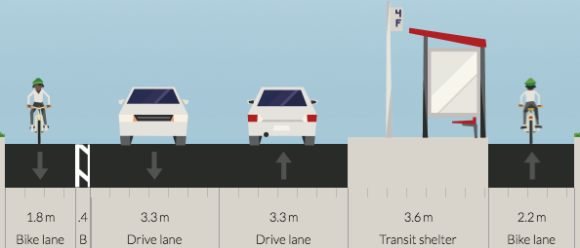
Through this segment, there is no reason to expose westbound cyclists to conflicts from parking cars and stopping buses. Moving the car parking and the bus stop to the left side of the bike lane through this segment would make it completely conflict-free.
In this situation, I allocated a bit more space to the westbound bicycle lane, since moving the parking to the left side creates a physical barrier that would prevent overtaking if the path were not sufficiently wide.
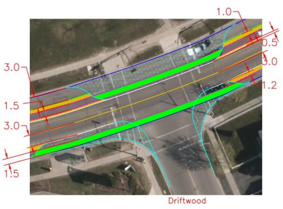
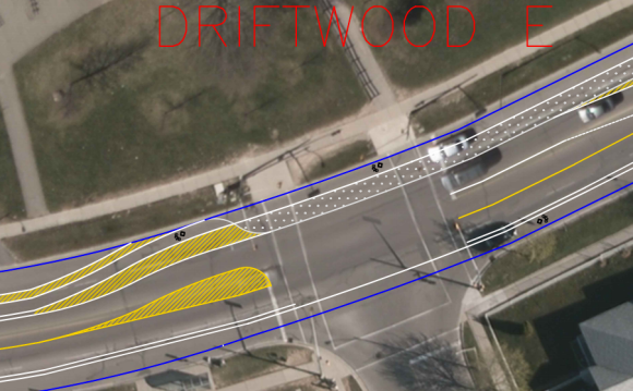
The city is proposing a fairly extensive reconstruction of the signalized T intersection with Driftwood Drive. The design shown in the March 2015 public consultation (below) includes curb extensions to reduce pedestrian crossing distance and slow turning motorists.
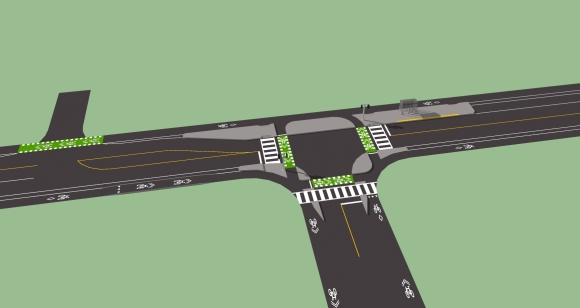
The big missed opportunity here is that westbound bicycles are controlled by the traffic light, even though there are no conflicting vehicle movements. Providing a pedestrian island between the bicycle path and the intersection allows it to be completely independent, with the pedestrian conflicts controlled with a simple priority arrangement (pedestrians yield to bicycles or vice versa).
An other side effect of the bicycle path being immediately adjacent to the roadway is that there is no apparent way for westbound cyclists to turn left onto Driftwood. If the path were further away, there would be room for turning cyclists to wait for the signal onto driftwood without blocking people travelling straight along Westheights.
Then there’s the issue of turning conflicts with eastbound drivers. The bike lane travels straight through the intersection, which results in cyclists approaching turning motorists in their blind spot. Shifting the bicycle path away from the intersection would make for better sightlines between both sets of road user.
Additionally, the bus stop could be moved from its current midblock location to the signalized intersection to provide a safe crossing opportunity for pedestrians accessing the stop.
Here’s what these ideas all look like put together.
Interestingly, the design shown in the “proposed design” sheets is different than the design shown at the consultation, including a left turn lane and a pedestrian island between the westbound bicycle lane and the intersection. But it still lacks any way to turn left onto Driftwood, and still has an unsafe angle of conflict between eastbound cyclists and motorists.
And it still places cyclists in conflict with parking cars and stopping buses for no apparent reason.
This roadway redesign is a great step in the right direction for a collector street such as Westheights. It demonstrates that the City of Kitchener is learning from its experience with previous road diets, most notably through the width of the bicycle lanes and the separation from parked cars. Just a few little changes would take what is already a very good design and transform it into an excellent one.

6 replies on “Critique of Westheights Drive road diet plan – Kitchener”
Very thoughtful design – by citizens, for citizens! Thanks for sharing. I’m curious what software/how you created your bird’s eye view design showing the combination of all your ideas?
LikeLike
I use SketchUp for my renderings, I find it’s quite quick and easy to use. I downloaded the traffic signals and bus shelter from the SketchUp warehouse, and I followed the pavement marking designs from the Ontario Traffic Manual, which you can find on my “Links” page. I referred to books 11 (Pavement Markings) and 18 (Cycling Facilities) for this particular design.
LikeLiked by 1 person
Your designs are good, but I still have a few ideas. I would move the bus stop to the far side of the intersection to reduce the impact of the traffic light. If there was room, you could make this a mini roundabout looking something like this: http://1.bp.blogspot.com/-7vY8pEyz4r0/UX_QQBj2raI/AAAAAAAADH4/6AiJ8YR0rA8/s1600/roundabout.jpg. Because the Dutch are masters on cycle path design, they know how to combine even many driveways and cycle tracks. Here is a link to how they design them: https://bicycledutch.wordpress.com/2011/08/18/but-we-have-driveways/. Because this street is still relatively important and cyclists need shielding to any speeds above 30 km/h in urban areas, and cycle lanes are too invadable, plus the conflicts with parking being on the right hand side of the buffered bike lane, I use cycle tracks even midblock with driveways. I made a cross section here: http://streetmix.net/-/271172.
You are getting good, but you could still reach for the stars instead of the moon.
LikeLike
Bus stop: Good point! That makes sense, plus it would free up space on the westbound approach for a left turn lane which benefits traffic movement!
Roundabout: Also a good point, it’s quite a wide intersection so there may well be space for a proper Dutch roundabout. But if it isn’t big enough to do it perfectly, I’d probably hesitate to add one since it would be a new concept to drivers. The British rendering you linked to is sub-par because it does not provide a 5 metre buffer between the bicycle path and the circular carriageway. As a result there is not room for a vehicle to yield to cyclists while exiting without blocking circulating traffic, and more importantly, the angle of conflict is horrible so it would be easy for an exiting driver to not notice an approaching cyclist. I think the two roundabouts in UW north campus would be ideal candidates to introduce the Dutch design since there is tons of space and the University could be involved in studying their operation.
Driveways: It is definitely true that cycle tracks and driveways can safely co-exist, my comment was more along the lines of “that’s a valid excuse, I’ll let it slide for now”. Introducing a safe design with cycle tracks would require moving curbs along the entire street, which is way beyond the budget of the project so there’s no point in asking for it today. And the subjective safety would be pretty good anyway with buffered bike lanes and much slower motor traffic.
Strategy: I am deliberately proposing designs that are within reach of the projects that are currently underway. I think it’s easier to get designs changed if we focus on a few aspects of design. I’m concerned that if we come in with a proposal that is completely different from anything staff has ever seen we will get dismissed simply because they don’t want to deal with all the work and learning that would be associated with implementing it.
A lot of traffic engineering is based on local precedent, so for example once we have an example of a functioning protected intersection here it will not be such a big deal on another project to ask for a protected intersection and then focus on accommodating driveways along with cycle tracks.
Finally, I don’t reach for the stars on Westheights Road because, well, it’s just Westheights Road. Unlike King Street or University Avenue, it is not a particularly important piece of the bicycle network, it mostly serves a local access function. There is not an infinite amount of community support (notably in terms of time – this is not my full time job, for example), so I would generally reserve all-out efforts for critical projects whose scope makes it possible to achieve excellence (i.e. road reconstructions on major bicycle routes).
LikeLike
You’re also allocating a bit too much space to cars in my opinion. 3.3m is a bit too wide, and is likely to encourage speeding. The extra space with parking cars can be used towards barriers. And 2.5 metres is really the standard we should want when building one way cycle tracks. On the cross section at the top of the blog post, I reorganized the space like this: http://streetmix.net/-/282519 and the bus stop cross section like this: http://streetmix.net/-/282520. It makes it safer. And it is not actually bad to use a roundabout with not as much separation if you can’t get the full 6 metres of space, it is just less ideal. Why advocate for less when you could do more? If you are building a street you likely have to live with it for a long time.
LikeLike
3.3 is the absolute narrowest you can can go if you want to run a bus down the street. I don’t propose to remove the bus route.
LikeLike